Outdoor Visual Positioning
- Category: App
- Made with Flutter and ResNet-152
- Github Repo: https://github.com/AllisanLu/Building-Labeler
Experience
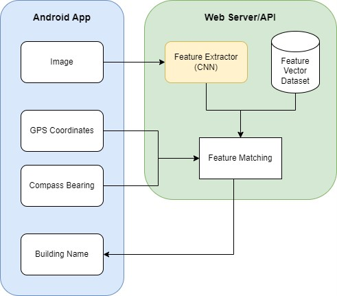
This project uses the pre-trained ResNet-152 model and localization information to create a more accurate and efficient Georgia Tech building labeler. By taking a phone's compass bearing and latitude and longitude coordinates, we are able to narrow down the buildings in the database the CNN does feature matching with. Not only are we able to eliminate buildings that would not be correct due to their location, we are also able to make the program more efficient by decreasing the number of matchings. With the addition of coordinates and compass bearings we increased the accuracy of the program from 72% to 86%.
For this app, we wanted it to be compatible on different phone types for testing purposes, so we used Flutter to develop it. To connect the app to the model, we used a server to host the model and had the app do API calls to send location information and photos then to recieve the name of the building as well.